Page 1 of 1
[SOLVED]no raster interpolation in Command Line
Posted: Mon Jan 01, 2024 11:38 pm
by PablerasBCN
Hi,
I suspect the interpolation is not working in command line.
Tested on the Jan 1 build too.
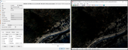
As you can see in the image, the irfan view picture is the one generated by the command line and is full of holes.
edit:
"for %%f in (E:\LIDAR_JAPAN\MMS8_Prototype_3\LIDAR\03_Compare_LIDAR_to_DEM_mesh\*.las) DO "C:\Program Files\CloudCompare\cloudcompare.exe" -SILENT -O -GLOBAL_SHIFT AUTO %%f -AUTO_SAVE OFF -NO_TIMESTAMP ^
-SET_ACTIVE_SF "Classification" -FILTER_SF MIN 1 -SET_ACTIVE_SF "C2M signed distances[<0.45]" -FILTER_SF MIN 0.4498 -RASTERIZE -GRID_STEP 0.5 -EMPTY_FILL INTERP -OUTPUT_RASTER_RGB
cmd /k"
Re: no raster interpolation in Command Line
Posted: Fri Jan 05, 2024 8:40 pm
by PablerasBCN
I installed the kyev, stable version and interpolation works.
So at some points things whent south.
Re: no raster interpolation in Command Line
Posted: Sun Jan 07, 2024 10:54 am
by daniel
Ok, so on my side both the GUI and the command line was behaving the same, but it was behaving badly! (the holes were not filled with a step of 0.5m, but they were filled properly with a step of 1m...).
This led me to discover that there was an issue with how the 'max edge length' parameter was used. This is now fixed.
Thanks for the feedback. I'll update the 2.13.beta release this evening.
Re: no raster interpolation in Command Line
Posted: Tue Jan 09, 2024 10:26 am
by PablerasBCN
Hello Daniel,
Teh issue persists in the Jan 7 build. I can upload a couple of sample clouds and .bats if it helps.
Re: no raster interpolation in Command Line
Posted: Tue Jan 09, 2024 10:21 pm
by daniel
And did you set the 'max edge length' parameter correctly?
Re: no raster interpolation in Command Line
Posted: Tue Jan 16, 2024 6:55 pm
by PablerasBCN
Apologies for hte late reply.
I did read your answer on time but I was a bit confused by it and I had no time to focus on this topic till today.
I was re checked the params of the command and the only required param is the grid step, that is why it called my attention that you whanted me double check the MAX_EDGE_LENGTH, which is optional, and in this case I was not interested in using.
[EDIT: i SEE IT IS NOW A MANDATORY TO USE WHEN USING INTERP!!!:
-MAX_EDGE_LENGTH {value} to specify a maximum triangle edge length for interpolation (to be used with -EMPTY_FILL INTERP) - since version 2.12 only]
Code: Select all
Rasterizes the loaded clouds by projecting them inside a regular grid.
Optional settings are:

-VERT_DIR {0/1/2} to specify the projection dimension (0=X / 1=Y / 2=Z) - default is 2 (Z)
-PROJ {MIN/AVG/MAX} to specify how the altitude of each cell is computed (minimum, average or maximum altitude of the projected points). Default is AVG (average)
-SF_PROJ {MIN/AVG/MAX} to specify how the SF value(s) of each cell are computed (minimum, average or maximum of the projected points SF value(s)). Default is AVG (average)
-EMPTY_FILL {MIN_H/MAX_H/CUSTOM_H/INTERP} to specify how empty cells should be filled (MIN_H = min height / MAX_H = max height / CUSTOM_H = custom value - see CUSTOM_HEIGHT option below / INTERP = interpolate). Default behavior is 'leave cells empty'
-MAX_EDGE_LENGTH {value} to specify a maximum triangle edge length for interpolation (to be used with -EMPTY_FILL INTERP) - since version 2.12 only
-CUSTOM_HEIGHT {value} to define the custom height filling value (if the 'CUSTOM_H' strategy is used (see above)
-OUTPUT_CLOUD to output the result as a cloud (this is the default option if no other output format is defined)
-OUTPUT_MESH to output the result as a mesh
-OUTPUT_RASTER_Z to output the result as a geotiff raster (only altitudes, no RGB)
-OUTPUT_RASTER_Z_AND_SF to output the result as a geotiff raster (altitudes + all SFs by default, no RGB)
-OUTPUT_RASTER_RGB to output the result as a geotiff raster (RGB)
Notes:

if OUTPUT_CLOUD or OUTPUT_MESH is selected, the resulting entity will replace the original cloud in memory
I'll now test with that param, yet if it works I beleive something should fixed as an optional param should not be mandatory.
Re: no raster interpolation in Command Line
Posted: Tue Jan 16, 2024 7:22 pm
by PablerasBCN
adding "-MAX_EDGE_LENGTH 0" fixes the issue, case closed. :D
I would suggest to add a note in the documentation that interpolation parameter requires the max edge lenght param, or make a 0, default if no max edge lengh param is input.
Re: [SOLVED]no raster interpolation in Command Line
Posted: Thu Jan 18, 2024 10:31 am
by daniel
Yes, I've just updated the wiki (the command line keeps the default values of the GUI version).